
TETIS
Model of hydrological and hydraulic simulation of physically distributed type, based and oriented to mountain watersheds
Description
Characteristics
Images
Download
Description
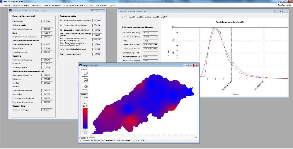
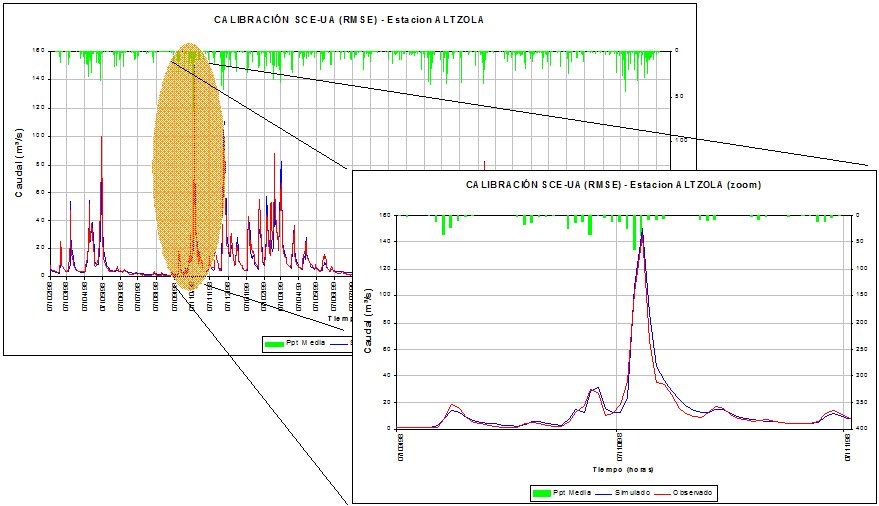
The TETIS model is a model of hydrological and sediment simulation distributed in space by a subdivision of the watershed into regular cells, with physically based parameters. It is an integral model, i.e., with the same model it’s possible to solve problems of both floods and erosion (temporal discretization of minutes or hours) and water resources (daily temporal discretization). In addition, it has a powerful automatic calibration algorithm of its effective parameters and the initial values of all state variables, which greatly facilitates its practical implementation. For the introduction of the information and visualization of results, it has an interface developed in the Visual Studio environment.
The advantages of distributed modeling with respect to the traditional aggregate and semi-distributed modeling consist mainly of:
- A better representation of the spatial variability of the phenomena involved within the Hydrological Cycle, through its inputs and parameters.
- The obtaining of results at any point of the watershed, without prefixing them beforehand and without the need of interpolations.
- The exploitation of all available spatial information, increasingly abundant thanks to the development in recent years that have had digital cartography, geographic information systems and measurements with remote sensors.
In its more than 20 years of history, the model has been widely used in Spain and other countries of the world. TETIS has been implemented in watersheds of all sizes, from less than 1 km2 to 98,500 km2 of the Rhone river in France, with spatial resolutions of 30 to 500 m and covering a wide range of climates, from arid to humid with applications in tropical and alpine climates. It should be noted at this moment that the TETIS model is operational as a model for predicting floods in the SAIH of the Basque Water Agency, and at the same time served as a basis for the estimation of water resources of the Autonomous Community of the Basque Country.
Characteristics
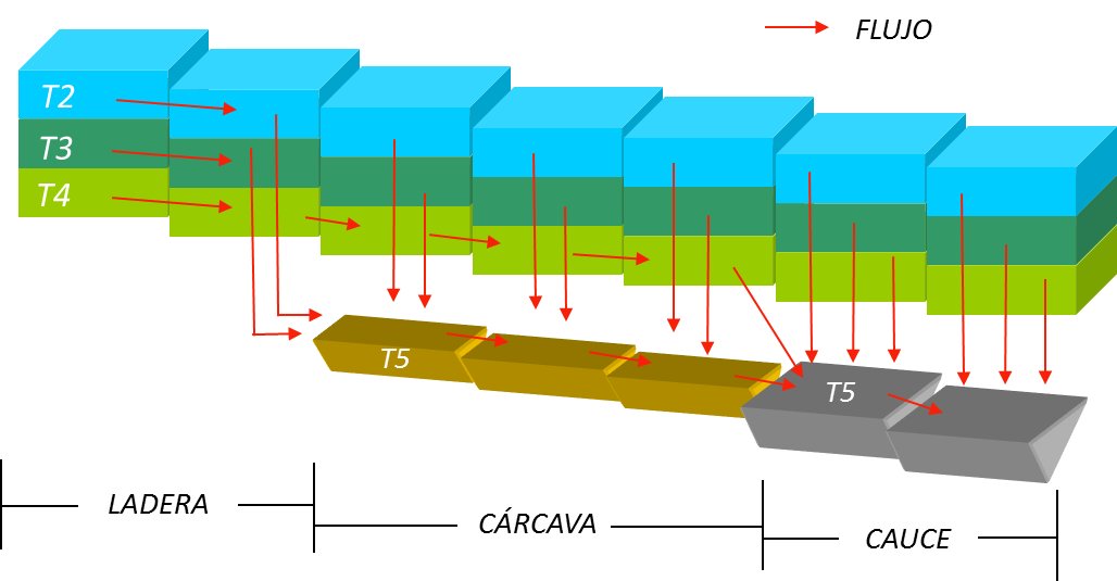
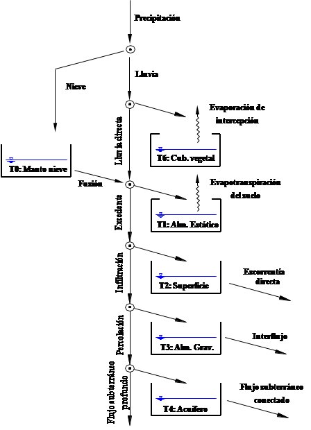
The hydrological sub-model is based on a tank structure in each cell, interconnected vertically and horizontally, representing hillside and aquifer processes. The aquifer process is represented by a single tank, while the hillside processes is subdivided into five tanks: snow cover, interception, surface storage andl capillary and gravitational storages of the upper soil. The result is the representation of most of the hydrological processes: interception, snow melting, evapotranspiration, infiltration, direct runoff, percolation, interflow, base flow and deep underground flow.
Direct runoff, interflow and base flow are connected to the river network by defining two threshold areas. The river network is divided into gullies and channels. Hillsides (direct runoff and interflow) are connected to the network of gullies, and only when there is base flow, the aquifer is connected to the network of channels. The propagation in the fluvial network is solved by the Geomorphological Kinematic Wave.
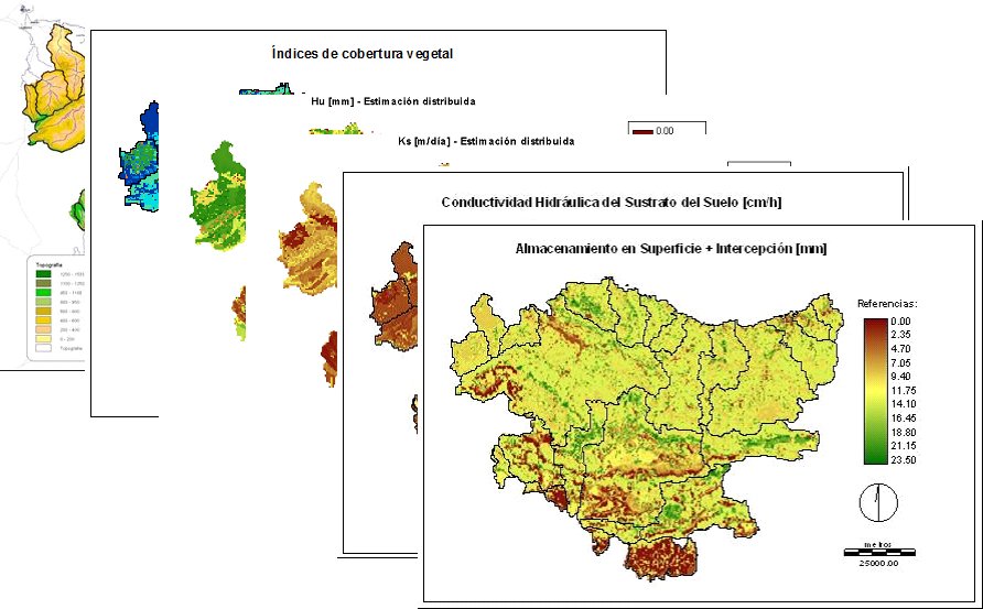
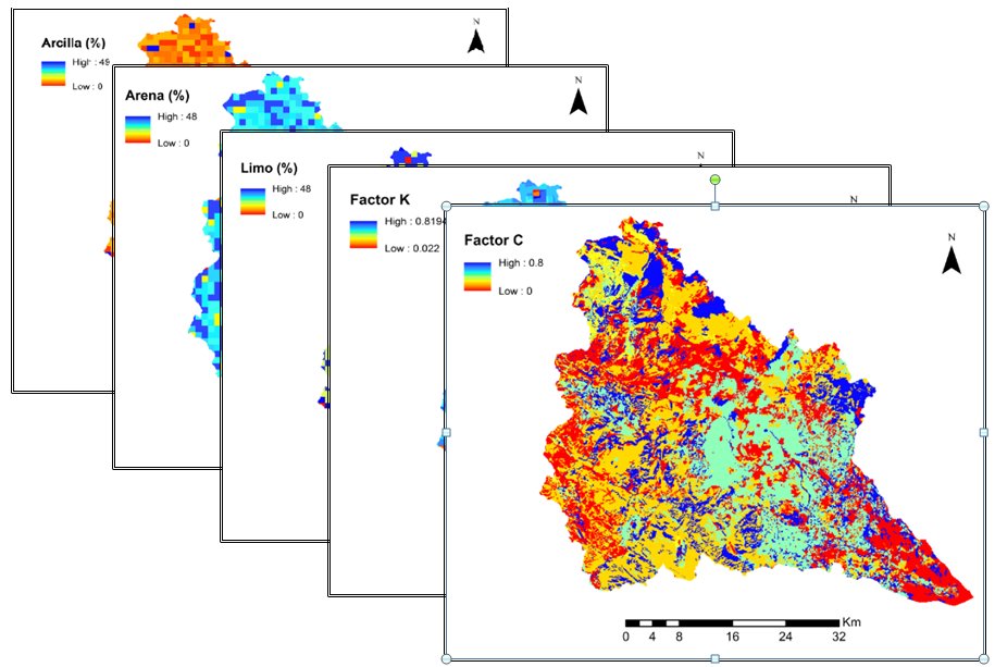
The input information necessary for model execution is based on temporary series of precipitation, potential evapotranspiration and temperature (the latter for the sub-model of snow melting). As for the cartographic information, the raster type format is used. It requires a digital elevation model and maps with the characteristics of the soil and subsoil. The latter is obtained from soil studies, vegetation cover, geological maps, edaphological information, hydrogeological maps and other environmental topics that may be of interest and that are available for the area of study.
The TETIS model presents a split structure for its effective parameters, thus, the effective value in a cell of a parameter is the result of the multiplication of the value of the corresponding map by a correction factor, which is common for all cells and different for each parameter. Therefore, the number of variables to be calibrated is reduced to 9 (eight hillside and aquifer processes and one of propagation in the river network). These correction factors are the values that must be found through automatic calibration.
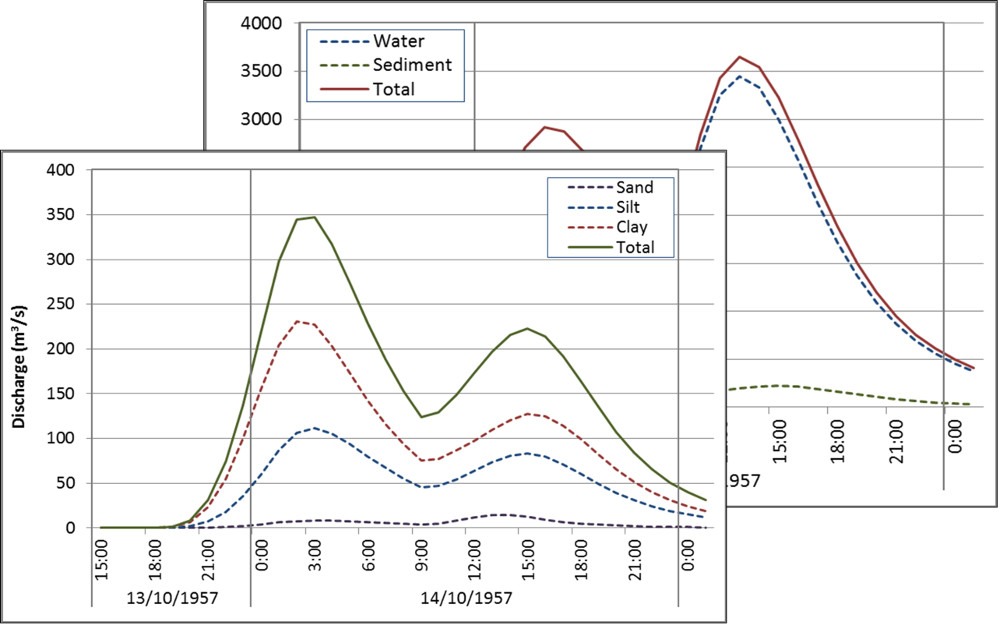
The sedimentological sub-model is based on the formulation of the CASC2D-SED model. This model simulates the hillside sediment processes in two dimensions, while in channels the approach is one-dimensional. In the TETIS model, both processes are one-dimensional. The production, transport and sedimentation rates are controlled by the availability of sediments in the watershed and the current transport capacity. Usually, the transport of fine materials is limited by the availability of sediment, while the transport of coarser materials is limited by the transport capacity of the flow.
TETIS model differentiates between hillsides, gullies and river channels and separates sediment particles into three categories of size, sand, silt and clay, each with different physical characteristics. In this way, the water velocity required for a particle to move and its fall velocity depend on its size.
Images
Download
The software can be downloaded from the following group website: https://gimha.upv.es/software/